


Geography
- ホーム
- English
- Introduction
- Geography
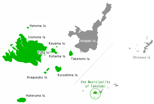
Many Isles,One Town
The municipality is composed of sixteen island of various sizes located in stretch of sea southwest of Ishigaki in the large arc of the Yaeyama Islands. Approxmately, it sits at 45 degrees north latitude, 450 Km southwest of Okinawa.
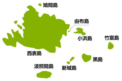
Notable islands it includes are Iriomote(the second largest island in the prefecture of Okinawa),
Yubu, Hateruma(Japan's southernmost inhabited island), Taketomi, Kohama, Kuroshima, Hatoma,
Aragusuku(in the local language known as Panari), and Kayama.
Location
The town of Taketomi is part of Yaeyama County, the southernmost county in the Ryukyu Archipelago.
Its sixteen island lying southwest of Ishigaki island—nine of which are inhabited, and the other seven of which are not—stretch 42 Km from east to west and 40 Km north to south.
What is unique about its administrative style is that its municipal office is located within the neighboring city of Ishigaki at the center of regional economy.
| Easternmost Point (Taketomi Island) |
Latitude of 24º 19´ 15˝ N Longitude of 124º 6´ 7˝ E |
|---|---|
| Westernmost Point (Nakanougan Island) |
Latitude of 24º 11´ 33˝ N Longitude of 123º 33´ 18˝ E |
| Southernmost Point (Hateruma Island) |
Latitude of 24º 2´ 44˝ N Longitude of 123º 47´ 18˝ E |
| Northernmost Point (Hatoma Island) |
Latitude of 24º 28´ 38˝ N Longitude of 123º 48´ 58˝ E |
Climate
Located in the southern reaches of the East China Sea and surrounded by ocean, the municipality has had anbaverage yearly temperate of 24.0℃ in the previous yearse—experiencing relatively little change in temperature throughout the four seasons—and its average humidity and mean annual precipitation 78.7% and 2,111 mm (83in) characterizing its humid subtropical climate.
Precipitation levels rise particularly in the rainy season in early summer and the typhoon season in late summer (July-September), both of which bring torrential rainfall. However, the island may experience drought in a year of few typhoons.


- 〒907-8503 沖縄県石垣市美崎町11番地1
Tel:0980-82-6191(代表) Fax:0980-82-6199(代表)
Copyright © Taketomi Town. All Rights Reserved.